Kolida K6 Rtk Imu Newly Upgraded Gnss Rtk for Measuring
Description
| Product Name: | DGPS | Operation System: | Linux |
|---|---|---|---|
| Transport Package: | Carton | Production Capacity: | 1000set/Month |
| Model NO: | K6 | ||
| Highlight: | K6 Rtk Imu Gnss Rtk
, Kolida K6 Rtk Imu , Measuring Kolida K6 Rtk Imu |
||
Kolida K6 1598 Channels Rover and Base Cheap Price with High Efficiency Land Surveying Instrument Rtk
K6
Models:K6

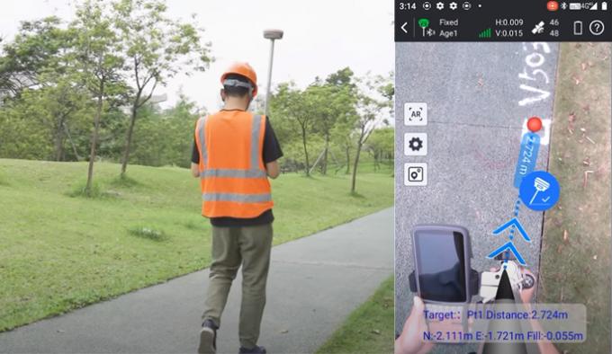
Stakeout More Intuitively
Combines real-time image display with RTK positioning, K6 captures real-time video through its built-in camera, and users can directly see the points to be setout on the collector screen, which is accurate and intuitive.

Best-in-Class GNSS Positioning Engine
The integrated advanced 1598-channel GNSS technology helps K6 to collect signal from GPS, Glonass, Beidou, Galileo, QZSS, in particular the latest BeiDou III. It greatly improved the data quality and satellite signal capturing speed of GNSS surveying.
Simpler and Easier, IMU Newly Upgraded
Many GNSS RTK systems require users to perform complex settings and calibration before doing inertial tilt measurement.
After the latest program was applied to K6, users only need to walk a few steps to activate the inertial sensor. This improvement makes measurements simpler and faster.
Farlink Radio, Built-in Transmitter
K6 is equipped with a 2W farlink radio transceiver, in optimal condition the working range can be as far as 8km even more.
Compack Design Rugged & Durable
K6 is a full-funcition GNSS RTK that has Radio, Bluetooth, Wi-fi, NFC modules onboard, can work as base and rover, but the receiver size is really small, only 13x 13 x8 cm.
The built-in 6800mAh battery and Intellegent power management program allow K6 to work up to 12-15 hours (Rover mode and Static mode).
Ultra Light,Comfortable Experience
The Total weight of K6 is only 0.8 kg including battery. The light-weight design reduces surveyor’s fatigue, increase their mobility, is especiallyhelpful to work in challenging environment.
| Satellite Tracking Ability | ||
| Channels1598 channels | ConstellationGPS, GLONASS, BEIDOU, GALILEO, QZSS, SBAS | L-BandB2b (for Asian-Pacific Area, need subcription) |
| Positioning Output Rate1-20 HZ | Initialization Time2-8 s |
|
| Positioning Precision | ||
| UHF RTKHorizontal ±8mm +1 ppm Vertical ±15mm +1 ppm |
Network RTKHorizontal ±8mm +0.5 ppm Vertical ±15mm +0.5 ppm |
|
| Static and Fast-StaticHorizontal ±2.5mm +0.5 ppm Vertical ±5mm +0.5 ppm |
|
|
| User Interaction | ||
| Operation SystemLinux | Built-in Camera2MP, view field 70 degrees | wifiYes |
| Voice Guideyes, 8 language | Data Storage4 GB internal, 32 GB external | Web UIYes |
| Keypad1 physical button & 5 Indicator Lights | ||
| Working Capability | ||
| RadioBuilt-in transmitting and receiving, 2W | Tilt Survey Inertial Measurement, up to 60 degrees tilt angle |
Electronic BubbleYes |
| Enduranceup to 12-15 hours (rover and static mode) |


Reviews
There are no reviews yet.