


Subtotal: $7,110


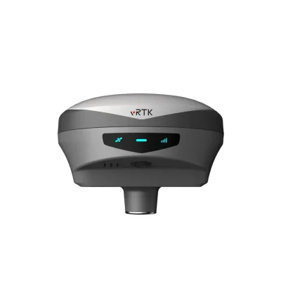
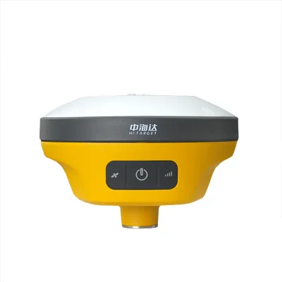
Hi-Target V200 RTK GNSS Receiver Bluetooth / Wi-Fi Communication
In Stock
$2,000
In Stock
Description
Detail Information
| Products Name: | GNSS RTK System | Channels: | 800+ |
|---|---|---|---|
| Tilt Survey Performance: | 60° | Communication: | Bluetooth/Wi-Fi |
| Internal UHF Radio: | Frequency | Operation Temperature: | -30°℃~+70° |
| Storage Temperature: | -40°℃~+80° | ||
| Highlight: | V200 RTK GNSS Receiver
, Wi-Fi Communication RTK GNSS Receiver , Bluetooth GNSS RTK System |
||
Product Description
Hi-target V200 2022 NEW Compact Design 800+ channels GPS RTK system Hi target V200 surveying equipment
A Simple but not Simplistic GNSS SystemV200 is a full-featured, intelligent GNSS receiver systemequipped with an integrated new-generation full-frequencyantenna and advanced multi-channel engine, allowingusers to attain accurate, reliable solutions. Users can alsotake advantage of calibration-free tilt compensationtechnology without leveling the survey pole to collect pointdata in more places. In addition, the Smart Base function inV200 automatically pairs the Rover with the Base by usingHi-Target global servers and ensuring communication byproviding the best connection.The V200 system can maximize your productivity inunprecedentedly challengingenvironments with these powerful features and Hi-SurveyRoad Field Software.
Good things come in small packages
V200 GNSS RTK Receiver brings superior performance and high efficiency to sup-
port your fieldwork with reliable solutions. Its deployment of the advanced RTK
engine and new-generation IMU guarantees a 25% performance improvement even
in the most demanding environments. Thus you can count on Hi-Target V200 for
better productivity
Higher Accuracy and Precision
Equipped with the High-Performance Patch Antenna,
enhances the low elevation angle tracking capabilities
and keeps it maintaining a high gain for higher elevation
satellites while tracking low-elevation satellites.
|
TECHNICAL SPECIFICATIONS
|
||
|
GNSS Feature
|
Specification
|
|
|
GNSS Signal
|
Channels
|
800+
|
|
GPS
|
L1/L2/L5/ L2C
|
|
|
BDS
|
B1/ B2/ B3/ B1C / B2a
|
|
|
GLONASS
|
L1/ L2/ L3
|
|
|
Galileo
|
E1/E5 AltBOC / E5a / E5b / E6
|
|
|
SBAS
|
L1/L5
|
|
|
QZSS
|
L1/L2/ L5/ L6
|
|
|
IRNSS
|
L5
|
|
|
Positioning Performance
|
High-precision static GNSS Surveying
|
Horizontal:2.5mm + 0.1ppm RMS Vertical:3.5mm + 0.4ppm RMS
|
|
Static and Fast Static
|
Horizontal:2.5mm + 0.5ppm RMS Vertical:5mm + 0.5ppm RMS
|
|
|
Post Processing Kinematic
|
Horizontal:8mm + 1ppm RMS Vertical: 15mm + 1ppm RMS
|
|
|
Initialization time: Typically 10 min for base and 5 min for rover
|
||
|
Initialization reliability: Typically>99.9%
|
||
|
(PPK / Stop & Go)
|
Horizontal:+0.25m+1ppm RMS
|
|
|
Code Differential GNSS Positioning
|
Vertical:+0.5m+1ppm RMS | SBAS:0.5m (H), 0.85m (V)
|
|
|
Real Time Kinematic (RTK)
|
Horizontal:8mm+1ppm RMS Vertical: 15mm+1ppm RMS
|
|
|
Initialization time: Typically <10s Initialization reliability: Typically > 99.9%
|
||
|
Time to first Fix
|
Cold start:< 45 s| Hot start:< 30 s| Signal re-acquisition:< 2 s
|
|
|
Hi-Fix
|
Horizontal: RTK+10mm /minute RMS Vertical: RTK+20mm /minute RMS
|
|
|
Tilt Survey Performance
|
Additional horizontal pole-tilt uncertainty typically less than
|
|
|
8 mm +0.7 mm /”tilt (2.5cm accuracy in the inclination of 60°)
|
||
|
Communication
|
Communication
|
Bluetooth:4.2/2.1+EDR, 2.4GHz
|
|
Wi-Fi: frequency 2.4GHz, Supports 802.11 b/g/n
|
||
|
Internal UHF Radio
|
Frequency:410-470MHz | Channel:116 (16 scalable)
|
|
|
Transmitting power:0.5W /1W /2W adjustable
|
||
|
Supports multi-communication protocols: HI-TARGET, TRIMTALK450S,
|
||
|
TRIMMARK III, TRANSEOT, SATEL-3AS, etc.
|
||
|
Physical
|
Internal battery
|
Internal 7.4V /6800mAh lithium-ion rechargeable battery.
|
|
RTK Rover (Network) for 12 hours. | Static: up to 15 hours
|
||
|
External power
|
Power consumption:4.2W | Dimensions (WxH):132mmx67mm
|
|
|
Charging: using standard smartphone chargers or external power banks.
|
||
|
Weight:50.8kg (includes battery) Data storage:8GB ROM internal storage
|
||
|
Control Panel
|
LED Lamp
|
Satellite, Signal, Power
|
|
Physical button
|
1
|
|
|
Environment
|
Water / Dustproof
|
IP67
|
|
Shock and vibration
|
Designed to survive a 2m natural fall onto concrete
|
|
|
Humidity
|
100%, condensing
|
|
|
Operation temperature
|
-30°℃~+70°
|
|
|
Storage temperature
|
-40°℃~+80°
|
|
|
I/O Interface
|
1 x USB port, Type C
|
|
|
1 x SMA antenna connector
|
||
|
Data Formats
|
Output rate
|
1Hz-20Hz.
|
|
Static data format
|
GNS, Rinex
|
|
|
Network model
|
VRS, FKP, MAC; supports NTRIP protocol
|
|
|
CMR& RTCM
|
CMR, RTCM 2.x, RTCM 3.0, RTCM 3.2
|
|
|
Navigation outputs ASCII
|
NMEA-0183
|
|


Reviews
There are no reviews yet.